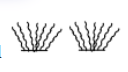
Concept:Topographic maps use conventional symbols to represent physical and human features.Explanation:The symbol shown is used on topographic maps to mark low-lying land that is likely to be covered by water during flooding. It does not represent permanent swamp or marsh, nor settlements or farmland.Answer:D. areas liable to flood.