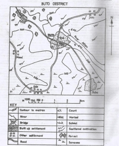
Concept:A transport mode can be identified by studying the lines and connections shown on a map.
Explanation:Looking at the mapped area, the main feature is a network of roads linking settlements.
The road routes spread out and connect many villages and towns.
Rivers are limited and do not join most of the settlements shown.
Rail and air routes are absent or not clearly represented in the area.
Because roads offer the most common and widespread connections, road transport is used by the people in that area.
So among the given choices, the mode commonly used in the mapped area is road.
Answer:B. Road