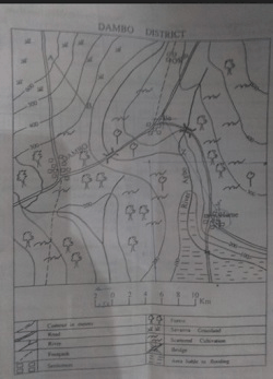
Concept:Road distance is the actual length of the road route between two settlements, measured along curves and bends using the map scale.
Explanation:On the map of Dambo District, first locate the settlements of Dambo and Hume.
Carefully trace the road connecting Dambo to Hume with a thread, string, or a paper strip.
Mark the end point of the traced road and straighten the thread or paper.
Measure this traced length using a ruler, in centimetres or inches.
Use the map scale to convert the measured length into real ground distance.
Since the road is curved, never measure straight-line distance between the two settlements.
After converting the traced road length with the scale, the approximate distance is found to be
20 km.
Therefore, the correct option is C.
Answer:C.
20 km