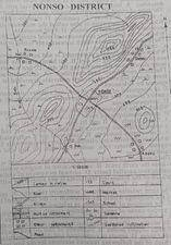
Concept:Identify the highest contour value or spot height shown on the map.Explanation:The highest point on the mapped area is marked by the top contour line or spot height.This elevation is approximately 1250 metres above sea level.All other visible heights on the map are lower than this value.Answer:B. 1250 metres