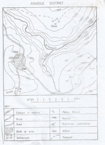
Concept:The map symbols show the transport routes available in the area.
Explanation:By studying the map, the main features are roads and water bodies.
Roads are shown as continuous lines that connect different places.
Rivers or lakes are also visible and can be used for movement by boats.
No railway lines appear on the map, so railway transport is not common.
There are no pipelines indicated, and no airport is shown for air transport.
Therefore, the dominant transport modes in the mapped region are road transport and water transport.
Answer:C. Road and water